

Eastern Plains Land Ownership Unit Maps
Price range: $19.95 through $29.95
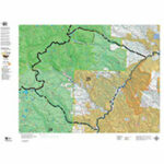
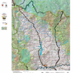
The Eastern Plains Digital Maps display private land State Lands and Colorado Parks and Wildlife managed properties. These properties are critical as they off public hunting access.
Additional information
| Weight | 1 oz |
|---|---|
| Eastern Plains Units | 87, 88, 89, 90, 91, 92, 93, 94, 95, 96, 97, 98, 99, 100, 101, 102, 103, 104, 105, 106, 107, 108, 109, 110, 111, 112, 113, 114, 115, 116, 117, 118, 119, 120, 121, 122, 123, 124, 125, 126, 127, 128, 129, 130, 131, 132, 133, 134, 135, 136, 137, 138, 139, 140, 141, 142, 143, 144, 145, 146, 147 |
| Print Options | Rugged Fabric (29.95), Tear-resistant paper (19.95) |
Reviews (0)
Only logged in customers who have purchased this product may leave a review.
Shipping & Delivery
Reviews
There are no reviews yet.